


Crimson
Smart operation management
Designed and developed in Europe using sovereign technologies, Crimson is a leading product line in the defence and security markets for collaborative and innovative command of:
- Hypervision, protection and defense operations of public and natural spaces, as well as critical infrastructures and systems.
- Military operations and force management.
- From day-to-day operations to incident and crisis management.
- Resilience of infrastructures and territories.
A true multi-domain, data centric C2/C4ISR system, Crimson leverages the latest technologies, including digital twins, simulation, extended reality, and artificial intelligence, to facilitate situational awareness, information sharing, coordination, command, and decision support.
Crimson provides a comprehensive and intelligible situational awareness, intelligent operational assistance, and an intuitive interaction between all stakeholders and third-party systems (sensors, effectors, VMS, CMS, C2s, drones...), in multi-organizational and multi-level operations.
The OODA loop
Born out of military strategy, it consists in:


For all defense and security stakeholders
- Command centers, from headquarters to frontline
- Field units and first responders
- Authorities, operatiors, and security/saftey stakeholders
Numerous
benefits
- Intuitive and ergonomic digital-twin centric interface
- Data-centric architecture with secure data sharing
- Event logging, traceability, and after action review capabilities
- Fast configuration and easy onboarding
- Highly interoperable and secured by design
- Openness and scalability to meet business needs
4 TAILORED SOFTWARE SOLUTIONS
Innovative technological components
Developed by CS Group

High performance 2D-3D
mapping and Digital Twin engine
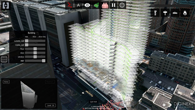
- Integration of GIS, CAD and BIM data
- Multi-source, multi-format data fusion and rendering
- Multi-scale and multi-layer display
- Geopositioned elements in real time
- Multi sensor data fusion
- Natural and graphical interaction with real systems

Graphic orchestrator
& Hybrid Artificial Intelligence
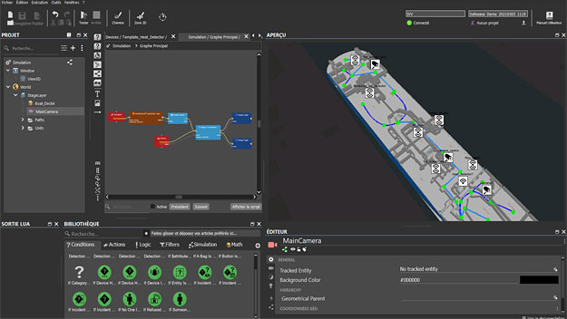
- No-code scenario authoring
- ConOps design and operation planning and assessment
- Configuration of standard procedures and doctrine for decision support and assistance
- Dynamic operator guidance
- Decision-support and automated system orchestration
Field Proven expertise
The Crimson products are not only at the cutting edge of innovation, they are also widely deployed and used in operational contexts for planning and managing operations in multiple domaines.


")
")